![[AUTO] Atlas V - image](/media?u=https%3A%2F%2Fthespacedevs-prod.nyc3.digitaloceanspaces.com%2Fmedia%2Fimages%2Fatlas_v_image_20201212013334.jpeg&w=1600)
United Launch AllianceAtlas V 401Space Launch Complex 3E, Vandenberg SFB, CA, USA
Landsat 8 (DCM)
Launched
February 11, 2013

Summary
Landsat 8 (DCM) launched on an United Launch Alliance Atlas V 401 from Space Launch Complex 3E, Vandenberg SFB, CA, USA on February 11, 2013. It was United Launch Alliance's 69th launch, 2nd this year and humanity's 5,277th orbital launch attempt. It was the 16th Atlas V 401 flight and the 2nd this year. The payload was bound for Sun-Synchronous Orbit (SSO). Landsat 8, one of 2 catalogued objects, reached a 674 × 691 km orbit inclined 98.2°. 2 objects from this launch are catalogued, one of them a payload.
- Watch
- Atlas V LDCM Launch HighlightsUnited Launch Alliance
- Vehicle
- Atlas V 401 · United Launch AllianceLandsat
- Booster
- No booster details on record.
- Mission
- Earth Science · Sun-Synchronous Orbit (SSO)for NASA
- Milestone
- 16th Atlas V 401 flight · 2nd this yearUnited Launch Alliance's 69th launch2nd this yearhumanity's 5,277th orbital launch attempt9th orbital launch attempt this year
Flight preview
Orbit: as tracked
Landsat 8 · NORAD 39084 · 2013-008 · Space-Track · tracking 1 of 2 objects
Show the numbers for orbit elements
- Object
- TBA - TO BE ASSIGNED
- Object ID
- 2013-008A
- Epoch
- 2013-02-11 19:01:55 UTC
- Mean motion
- 14.65419619 rev/day
- Eccentricity
- 0.001209
- Inclination
- 98.2453°
- Ascending node
- 114.7482°
- Arg. of perigee
- 299.5876°
- Mean anomaly
- 60.2426°
- Element set
- 999
- Rev at epoch
- 0
- B*
- 0
Perigee, apogee and period are Kepler figures from the catalogued mean elements, not a propagated state. Published orbit: SSO. Ascent drawn from padside's representative profile.
Catalogued objects
2 catalogued: 1 payload, 1 rocket stage; 1 still in orbit
- Landsat 8 · NORAD 39084 · in orbit
Centaur AV-035 · left Earth orbit February 12, 2013
Data from J. McDowell, planet4589.org
About this launch
Landsat 8 is an American Earth observation satellite launched on 11 February 2013. It is the eighth satellite in the Landsat program; the seventh to reach orbit successfully. Originally called the Landsat Data Continuity Mission (LDCM), it is a collaboration between NASA and the United States Geological Survey (USGS). NASA Goddard Space Flight Center in Greenbelt, Maryland, provided development, mission systems engineering, and acquisition of the launch vehicle while the USGS provided for development of the ground systems and will conduct on-going mission operations. It comprises the camera of the Operational Land Imager (OLI) and the Thermal Infrared Sensor (TIRS), which can be used to study Earth surface temperature and is used to study global warming.
News
 Boom Year for Desert BloomsCarpets of wildflowers burst from arid, ochre-colored land in Western Australia following winter rains.
 Indonesia’s Anak KrakatauAnak Krakatau erupts ash and volcanic gases in this Sept. 5, 2026, image acquired with the OLI (Operational Land Imager) on Landsat 8. Eruptions are a regular occurrence at Anak Krakatau, a small volcano between the Indonesian islands of Java and Sumatra. Much of its activity remains relatively mild, but it occasionally puts on more […]
 Anak Krakatau Rumbles AgainA powerful eruption from the Indonesian volcano lofted ash into the atmosphere, disrupting thousands of flights and degrading air quality.
 Bountiful Roebuck BayTidal and seasonal shifts leave their mark on this crescent-shaped, productive bay in Western Australia’s Kimberley region.
 A Tide-Fueled Trove of Biodiversity in Guinea-BissauThe expansive mudflats, sandy beaches, and mangrove forests of the Bijagós archipelago support an array of migratory shorebirds and large numbers of sea turtles.
 The Battle for Sullivan’s IslandMarshy, sandy terrain and an impassable inlet helped colonial forces repel British forces during a pivotal battle on the barrier island near Charleston, South Carolina, on June 28, 1776.
 Nebraska’s Wide, Rolling DomainThe Nebraska Sandhills—the largest system of sand dunes in the Western Hemisphere—stretch across about one-quarter of the state.
Pad
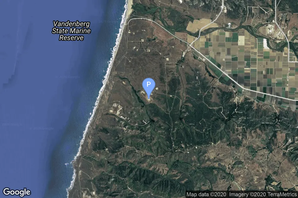
Space Launch Complex 3E, Vandenberg SFB, CA, USA
37th launch from Space Launch Complex 3E, 1st this year · 653rd from Vandenberg SFB, CA, USA
48 launches from this pad · 919 from Vandenberg SFB, CA, USA
150 days after the previous launch from this pad
Questions
When did Landsat 8 (DCM) launch?
Landsat 8 (DCM) launched on February 11, 2013. The time is known to the hour, not the minute.
Where can I watch Landsat 8 (DCM)?
Coverage: Atlas V LDCM Launch Highlights. Watch the replay
What rocket launched Landsat 8 (DCM)?
Atlas V 401, flown by United Launch Alliance. Atlas V 401 spec sheet
Where did Landsat 8 (DCM) launch from?
Space Launch Complex 3E, Vandenberg SFB, CA, USA.
What orbit did Landsat 8 (DCM) reach?
Landsat 8, one of 2 catalogued objects, reached a 674 × 691 km orbit inclined 98.2°.
How many satellites did Landsat 8 (DCM) launch?
1 payload from this launch is catalogued, still in orbit (Data from J. McDowell, planet4589.org).
Which program is Landsat 8 (DCM) part of?
Landsat. About Landsat